“Cartographers”
The process of forming a region is of special interest as a historical series of events. The first document to record the formation of Transcarpathia was the the Treaty of Saint-Germain-en-Laye. This document also reveals that the autonomous region to be created within Czechoslovakia is based on the territory of the former Rusyn (Ruthenian) population in northeast Hungary. The peace treaty did not even name the new administrative unit, with noble simplicity it was referred to as the territory of “the Ruthenians living to the south of the Carpathians”. Moreover, in various official documents dating back to 1919 the territory was given a confusing variety of names. While in Ruthenian and Czech this region was first called КарпатськаРусь, Karpatská Rus, then the forms ПодкарпатськаРусь and Podkarpatská Rus were used in documents, in the Hungarian-language documents, the reader could come across Karpatorussia, Karpato-Russia, Kárpáto Russia, Podkarpato-Russia, PodkarpatszkaRusz and even RuszkaKrajna. In the last hundred years the territory bordering on the Carpathian ridge, the Tisza and the railway became rich in events, legends that influenced people’s lives, thus forming a kind of bond with the territory, and becoming part of their identity. It is no coincidence and it has been confirmed in many researches that the Transcarpathian Hungarian community’s local Transcarpathian identity is stronger than its identity with the country. One cannot really wonder about it, since in the last one hundred years there was a tendency for countries to be eliminated in one way or another, while Transcarpathia underwent slight modifications, but remained. Were there prototypes of the hundred-year-old Transcarpathia? Why was it formed within the borders it was formed within? What alternatives were discussed at the peace conference after WWI concerning the prospects of the region?
Although the Ruthenians lived in different counties of the Hungarian Kingdom, their compact residential area was in the Eastern Carpathians, thus it is no coincidence that the issue of Ruthenian region’s “balling” had already been raised in the Habsburg Empire. At the turn of 1849-1850 Adolf Dobránszky, rapporteur of Ungvár (Uzhhorod) Parish uniting Ung, Bereg, Ugocsa and Maramures (Maramureș) counties planned the establishment of a Ruthenian autonomy and, what is more, annexation of the Ruthenian-inhabited areas to Galicia. These plans did not win favour with Vienna; moreover, the parish was liquidated. The territory inhabited by the Ruthenians who lived to the east of the Carpathians attracted great interest in XIX century in Galicia that was under the control of the Habsburgs, as well as in the Russian Empire. Mikhail Drahomanov and Ivan Franko wrote about them, Volodymyr Vernadsky, the first president of the Ukrainian Academy of Sciences that was established in 1918 dedicated numerous works at the end of XIX century to the territory inhabited by the Ruthenians and known as “Угорськарусь” (UhorszkaRus , Hungarian Rus). These were mainly scientific or socio-political argumentations. In the Russian Empire, the territory with a Russian name “УгорскаяРусь” (Uhorszkaja Rus, Hungarian Rus) attracted not only scientific, but also strategic interest. In the midst of Russian military successes during World War I in January 1915, one of the Tsar’s diplomats wrote in a memo that the new Russian – Austrian – Hungarian border should stretch next to Galicia and Bukovina, while the so-called “УгорскаяРусь” (Uhorszkaja Rus) should be under the rule of the Russian Empire. He added that this “would free the last part of the Russian nation from foreign yoke.” The quoted Foreign Affairs Secretary informed what exactly he means by “УгорскаяРусь” (Uhorszkaja Rus, Hungarian Rus). He specified in writing the counties he would gladly see wholly or partly in his empire: Abaúj, Sáros, Gömör, Szepes, Zemplén, Ung, Ugocsa, Bereg, Máramaros (Maramureș), what is more even Szatmár and Szabolcs.
Seeing the collapse of the Austro-Hungarian Empire, the Galician Ukrainian political leaders expressed their state-building aspirations and formulated their claims on the Ruthenian-inhabited territory onthe southern slopes of the Carpathians. On 13 November 1918, the Western Ukrainian People’s Republicadopted its interim Constitution that proclaimed independence, specified the desired borders of the state formation, and named the future, as they called them “former” Hungarian counties: Szepes, Sáros, Zemplén, Ung, Ugocsa, Bereg, Máramaros (Maramureș).
At the end of 1918, Hungary that was at war and on the brink of collapse attempted to organize Ruthenians into an administrative unit by means of establishing an autonomous region called Ruska-Krajna. This would unite the Ruthenian ethnic areas in Ung, Ugocsa, Bereg and Máramaros (Maramureș) counties, its southern border would stretch along Ungvár (Uzhhorod) – Munkács (Mukachevo) – Nagyszőlős (Vynohradiv) Máramarossziget (Sighetu Marmației). The Ruthenian autonomy experiment did not apply for the Ruthenians in Gömör, Sáros, Zemplén, and Abaúj counties, since there was a significant number of Slovak population in these counties, and the government of the People’s Republic had different plans for them.
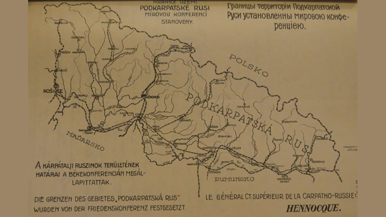
During the war-time collapse there were Ruthenian personalities who sought to spread and succeed in the local promotion of their views on the territories. Moreover, the American Ruthenians showed a vigorous activity on the affiliation of the highland area. However, the future of the region, as it is known, was decided in Paris, where for the first time the borders were specified to form a single region for the greater part of the Ruthenians for a long period of time.
At Paris peace conference the Czechoslovak peace delegation’s leader Edvard Beneš revealed the Czechoslovak claims to the Supreme Council of the conference on the first days of February 1919. By this time, the greater part of Czechoslovakia’s prospective territory was under the control of the Czechoslovakian army. In February, this peace conference’s Committee of Czech-Slovak affairs began to deal with the issue of Ruthenian-inhabited highland. The committee included people from all walks of life. Its members included an adventurous Italian marquis, an American historian, an English nobleman, a French general with experience in World War I, and a former Australian Prime Minister. The Committee minutes reveal that there arose multiple ideas on the future of the Ruthenian territory. The first was to annex the Ruthenians to the unfolding Ukrainian state that was beset on one side by the Soviets, and on the other by the Polish. The second proposition was to let them stay under Hungary’s control. The third suggestion was the Ruthenian autonomy plan within Czechoslovakia. According to the fourth offer one part of the territory was to be accessed to Czechoslovakia, while Máramaros (Maramureș) County was to be part of Romania. Furthermore, there emerged a proposition to let those living on the southern slopes of the Carpathians be under the control of Poland. The first two were soon ruled out by the Committee. The issue of establishing the Ukrainian state was a difficult case, because the Ukrainians, who were seeking independence, required territories, demanded by the newly created Poland, thus the support of the Galician Ukrainian control was highly questionable in Paris. The suggestion to leave the territory of the Ruthenians under the control of Hungary was discarded by everybody except the Italian delegate on the grounds that in such a case the rail connection between Czechoslovakia and Romania would not have been possible, which was a very important aspect of the Committee’s decision-making. The American delegates were the first to offer accession to Czechoslovakia. The US proposal included also making Czechoslovakia guarantee the Ruthenian autonomy and suggested making sure the Rusyns also welcomed this scenario. The British delegate welcomed the proposal on the grounds that this could prevent the area being separated from Hungary, Romania and Czechoslovakia. The French delegate assured his colleagues that “some enlightened elements of the Ruthenian population stated that they would willingly unite with the Czechoslovakians”. He remarked on this solution, “It is not perfect, but the most expedient.” The American, British and French delegates objected to the accession of any, even a small part of the Ruthenian territories to Romania, even if this would form not just Czechoslovak-Romanian, but also Romanian-Polish relations over the Carpathian passes. Their most voiced counter-argument was that it would be unfortunate to merge Greek Catholic and Orthodox Romanian Ruthenians into one state. The merger with Poland was mentioned, however in practice it was not a subject of debate. The conceptual decision on the affiliation of the Rusyns was made in February at the peace conference. In the Czech-Slovak affairs commission only the Italian delegate expressed dissatisfaction about the plan, however, he noted: “this solution is a bad one; however – all things considered – it is unfavourable for a hostile country [meaning: Hungary]”.
The reader will obviously notice that while we were dealing with the Ruthenians’ territory, it is a fact that the lowland part of Transcarpathia, as part of Podkarpatská Rus (Carpathian Ruthenia), formed on the territory of the first Czechoslovak Republic, was mainly populated by the Hungarians. From March 1919 to June 1919 the final decision was reached on the Czechoslovak – Hungarian border, which of course was followed by a lengthy on-site work of the border-determining commissions. In Paris, however, the most important principles were not adhered to. The above-mentioned facts make it clear that the most important factor in the formation of Transcarpathia’s southern border was the railway stretching along the Hungarian ethnic area which could ensure the railway connection between Czechoslovakia and Romania. This formed the basis for determining the affiliation of towns, villages, and communities. The American side expressed doubts as to whether a numerous Hungarian minority should be placed under Czechoslovak rule, noting that this could represent a threat of irredentism in the future. The committee, however, did not take into account the ethnic principle; in addition to the already presented economic and strategic arguments, it named another one: the necessity to weaken the enemy. The consequences are well-known.
Imre Szakál
historian, lecturer, research staff member
Ferenc Rákóczi II Transcarpathian Hungarian College of Higher Education
This work is the first part in the collection of articles “The hundred-year-old Transcarpathia” initiated by Tivadar Lehoczky Social Sciences Research Centre of Ferenc Rákóczi II Transcarpathian Hungarian College of Higher Education.
-
This article is also available in
 Українська
 Magyar